

Last Updated 1 hour ago by Kenya Engineer
On a typical weekday morning in Joska, the contradiction of Kenya’s metropolitan expansion is easy to see.
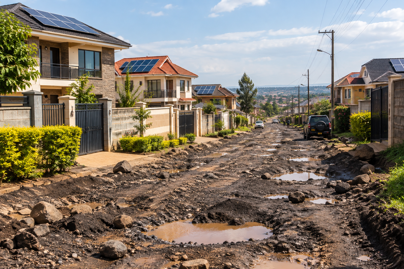
Behind walls and gates, new homes continue to rise. Some are substantial modern houses that would not look out of place in Nairobi’s established suburbs. Shops, schools, churches, workshops and other businesses have followed the residents. The population is growing and a community is taking shape.
Outside those compounds, however, the infrastructure can tell a very different story.
Some roads deteriorate into deeply potholed stretches where vehicles slow almost to walking pace, particularly after heavy rains. Drainage is inadequate in some areas. Public transport is largely road-dependent. Residents make their own arrangements for some services and, in some neighbourhoods, private initiatives fill gaps that would traditionally have been addressed through public infrastructure.
This is not unique to Joska. Across the wider Nairobi metropolitan region, communities in places such as Kitengela, Ongata Rongai, Juja, Ruiru, Mlolongo and other rapidly developing areas have experienced versions of the same phenomenon.
The houses have arrived. The people have arrived. The businesses have arrived. The infrastructure is often playing catch-up.
The question Kenya needs to ask is whether we are building communities faster than we are planning and building the infrastructure that will eventually support them.
The private city is arriving first
There is an important feature of this expansion that is easy to overlook. Much of the capital required to create these new communities is private.
A family buys land and builds a house. Another family does the same. A developer subdivides agricultural land. A shopkeeper establishes a business because there are now hundreds of potential customers nearby. A school opens because there are children. A church is established because there is a congregation.
Gradually, what began as a collection of individual developments becomes a functioning settlement.
This represents enormous economic activity. But it also creates a public infrastructure obligation.
Every new house potentially means additional demand for roads, drainage, water, waste collection, electricity, emergency services, schools, healthcare and public transport. Every new business creates additional demand for access roads, parking, waste management, security and other public services.
The planning challenge is therefore not how to control development. It is how to anticipate it.
Are counties also missing a revenue opportunity?
There is another side to this question that deserves considerably more attention.
Rapidly developing settlements are not only places where counties need to spend money. They are also expanding economic and revenue bases.
Property rates, development approvals, building-plan approvals, business permits, advertising fees and other charges can provide counties with own-source revenue.
A 2022 Commission on Revenue Allocation study estimated that Kenya’s counties had the potential to raise hundreds of billions of shillings annually from own-source revenue, including land rates, business permits and other charges. The Commission has subsequently urged counties to undertake comprehensive revenue mapping to identify their revenue potential.
The opportunity is particularly interesting in rapidly urbanising areas. A settlement that was largely agricultural ten or fifteen years ago may now contain thousands of homes, shops, schools, workshops and other businesses.
If the county’s revenue system still sees much of that territory primarily through its old land-use profile, it may not fully capture the economic transformation taking place on the ground.
This does not necessarily mean that counties are collecting nothing. Indeed, Machakos County is actively trying to strengthen revenue collection from land approvals, building approvals, advertisements and land rates.
The county has also launched what it describes as its first-ever draft valuation roll since the advent of devolution. The county says the exercise is intended to improve property valuation and significantly strengthen revenue collection.
That raises a more nuanced question.
How much revenue is actually being generated by these emerging communities, how much remains outside the revenue system, and how much of what is collected is subsequently translated into infrastructure and services in the places generating the economic activity?
Those are questions that deserve data rather than assumptions.
The resident who pays rates — and the neighbour who doesn’t
There is another complication. Compliance is unlikely to be uniform.
A property owner may faithfully pay land rates while a neighbour does not. A formally registered business may obtain its permits while another operates informally. One developer may obtain the necessary approvals while another may build without completing the formal development-control process.
This creates a peculiar situation. The county may simultaneously have: a growing taxable property base, imperfect compliance, increasing infrastructure demand and incomplete information about the actual development taking place.
That is not just a revenue problem. It is a planning problem.
A county cannot plan effectively for a settlement it cannot accurately measure.
This is why the development of property databases, valuation rolls, GIS systems, building-approval records and business registers could be much more important than they first appear.
Machakos already says its Lands and Physical Planning department maintains GIS capabilities and has been involved in spatial planning and infrastructure planning in several parts of the county. The county also identifies infrastructure provision for municipalities, towns and market centres as part of its urban-development responsibilities.
The opportunity is to connect these systems.
But what happens when someone applies to build a house?
This is perhaps the most important question. When a person obtains approval to construct a house in an emerging settlement, what exactly is the county approving?
Is it simply saying that the proposed building complies with building and land-use requirements? Or is the approval part of a wider spatial plan that considers what the surrounding area will look like when hundreds or thousands of similar developments are completed?
Kenya’s legal framework is actually more ambitious than a fee-for-approval model. The Physical and Land Use Planning Act requires development control to ensure orderly development, optimal land use and implementation of approved physical and land-use development plans. Counties have responsibility for controlling development and considering development applications.
More significantly, the law says that when considering development applications, counties must be guided by approved plans and take into account community facilities, environmental and social amenities and comments from relevant authorities.
For major development applications, the process can involve agencies responsible for roads and transport, health, public works and utilities, among others. The Act also specifically requires consideration of infrastructure adequacy in development control.
In other words, the law does not envisage development approval as simply collecting a levy and stamping a building plan.
The underlying principle is that development should fit within a plan.
That distinction matters enormously in a place such as Joska.
Planning for the house is not the same as planning for the neighbourhood
Approving an individual house may be relatively straightforward. The harder question is what happens when 500 houses are built. Or 5,000. Or 20,000.
A building can comply perfectly with its individual development requirements and still contribute to a larger infrastructure problem if the surrounding settlement has no adequate road hierarchy, drainage network, pedestrian system, public transport plan, sewerage system, public facilities or protected infrastructure corridors.
This is why local physical and land-use development plans are so important.
Under the Physical and Land Use Planning Act, such plans are intended not only to regulate land use but also to guide and coordinate infrastructure development and coordinate different sectoral agencies.
The law even requires consideration of infrastructure availability and adequacy when dealing with subdivision proposals and building development.
That means that, at least in principle, the county should be asking not only: Can this person build here? but also: What does this development mean for the infrastructure capacity of this entire area?
The opportunity is to plan ahead of the population
There is an opportunity for the country and the counties to move from reactive to predictive infrastructure planning. Instead of waiting until a road becomes impassable, a county could monitor development activity and identify emerging population centres.
Imagine combining building approvals, land subdivisions, electricity connections, water connections, property valuation data, business permits, satellite imagery, road traffic and population information.
The resulting data could show where development is accelerating.
An area with rapidly increasing building footprints, new businesses, rising electricity connections and growing traffic is clearly becoming something more than a collection of isolated homes.
It is becoming an urban node. That should trigger a planning response. Road reserves can be protected before they are occupied. Drainage corridors can be established before houses make them impossible to construct. Public land can be identified before land prices rise. Water and sewerage networks can be designed around anticipated demand. Street lighting can be planned rather than installed piecemeal. Public transport routes can be designed around emerging travel patterns. And infrastructure investment can potentially be prioritised according to where population growth is actually occurring.
This is where the emerging discipline of data-driven urban planning becomes particularly relevant.
From settlement growth to infrastructure investment
There is also a financing question.
If a county can identify where population and property values are increasing, it can potentially identify where its future revenue base is expanding.
That creates the possibility of a virtuous cycle. Better mapping produces better property records. Better property records improve revenue administration. Better revenue administration expands the county’s own-source revenue. Better information about population and economic activity improves infrastructure planning. Better infrastructure makes the settlement more productive and attractive. And greater economic activity potentially expands the revenue base further.
The alternative is a less productive cycle: development happens informally, revenue collection remains incomplete, infrastructure responds slowly, residents become dissatisfied and private residents begin providing their own solutions to public infrastructure problems.
Neither residents nor county governments ultimately benefit from that arrangement.
The metropolitan problem cannot be solved one county at a time
There is a further complication.
The people living in Joska are not necessarily part of a purely Machakos economy.
Many work in Nairobi. Others travel to neighbouring counties for schools, healthcare, shopping or business. The same is true for residents of Kitengela, Ruiru, Juja and other settlements surrounding Nairobi.
The functional metropolitan region therefore does not correspond neatly with county boundaries.
Kenya has recognised this for years through metropolitan planning initiatives involving Nairobi, Kiambu, Kajiado and Machakos.
The challenge now is to make metropolitan planning relevant to the new communities emerging along these corridors.
Machakos itself has established three municipalities — Machakos, Mavoko and Kangundo-Tala — and has been strengthening urban planning, drainage, connectivity, waste management and other municipal functions through programmes such as the Kenya Urban Support Programme.
The county is therefore not starting from zero. The question is whether similar planning capacity can keep pace with communities that may be emerging faster than formal urban structures are being established.
The next generation of Kenyan cities may already be here
Perhaps the biggest mistake would be to regard places such as Joska as “outskirts”. They are increasingly part of Kenya’s metropolitan economy.
The homes being built today are creating tomorrow’s neighbourhoods. The businesses opening today are creating tomorrow’s commercial centres. The roads being used today are becoming tomorrow’s transport corridors.
The question is whether infrastructure planning will recognise this transformation early enough.
Kenya does not necessarily need to stop people from building in these areas. Nor should every rapidly developing settlement immediately receive the infrastructure of an established city.
But there is a compelling case for doing something in between: identifying emerging settlements early, understanding their growth trajectory, integrating them into spatial plans and aligning revenue collection with infrastructure investment.
For counties, this could mean treating rapid settlement growth not just as a demand for more roads and services, but as an opportunity to expand the formal economic base.
For planners and engineers, it means moving beyond the approval of individual buildings towards planning the systems around them.
For developers and landowners, it means recognising that the value of a house ultimately depends not only on the building itself but on the quality of the community and infrastructure surrounding it.
And for residents, it means asking an equally important question of their governments:
If we are becoming a community, when does the government begin planning for us as one?
The answer should ideally come before the potholes, flooding, traffic congestion and service shortages become the evidence that the community has already arrived.

-
Product on sale
 AWEBook Volume 2Original price was: KShs 3,500.00.KShs 3,000.00Current price is: KShs 3,000.00.