

Last Updated 2 hours ago by Kenya Engineer
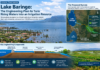
For more than a decade, Lake Baringo has been steadily expanding beyond its traditional shoreline, bringing water into areas that were once occupied by homes, farms, schools, roads and tourism facilities.
Now, rather than treating the rising lake levels purely as an environmental and disaster-management problem, Kenya is developing a more ambitious engineering response: controlling part of the excess water and directing it towards productive use in irrigation.
The proposed Lake Baringo flood-control and irrigation system is emerging as one of the more interesting water-engineering projects in the Rift Valley, combining hydrology, flood management, water conveyance and agricultural development.
The plans are still being developed, with detailed feasibility work and resource mobilisation underway. But the concept is becoming clearer.
The government is considering infrastructure to control and convey excess water from the Lake Baringo area towards downstream systems, while using the water to support large-scale irrigation in Baringo and potentially neighbouring counties.
The wider irrigation ambition is substantial. Government officials have said the project could eventually support irrigation across more than 100,000 acres, opening up significant agricultural potential in an area where water availability has traditionally constrained production.
A plan that predates the current phase
One of the important aspects of the proposal is that the idea of using Lake Baringo’s water for irrigation is not new.
In December 2024, the Ministry of Water, Sanitation and Irrigation and the National Irrigation Authority held consultations in Baringo to examine the potential of obtaining irrigation water from Lake Baringo.
The National Irrigation Authority reported that extensive studies had already been undertaken on water availability and soil suitability, with different proposals presented as possible pathways for developing irrigation projects. The Ministry subsequently planned further technical work to refine the proposals.
This places the current proposal within a longer process of investigating how Lake Baringo’s water could be integrated into the region’s agricultural economy.
The thinking is relatively straightforward: the same water that has become a challenge around the lake could potentially become a resource if it can be controlled, conveyed and distributed safely.
From flood control to water infrastructure
The current proposal has evolved beyond a conventional irrigation scheme.
Recent government assessments have been examining the wider hydrology of the Lake Baringo-Lake Bogoria basin and possible interventions for managing rising water levels.
The project is therefore being approached as a water-management system rather than simply a canal construction project.
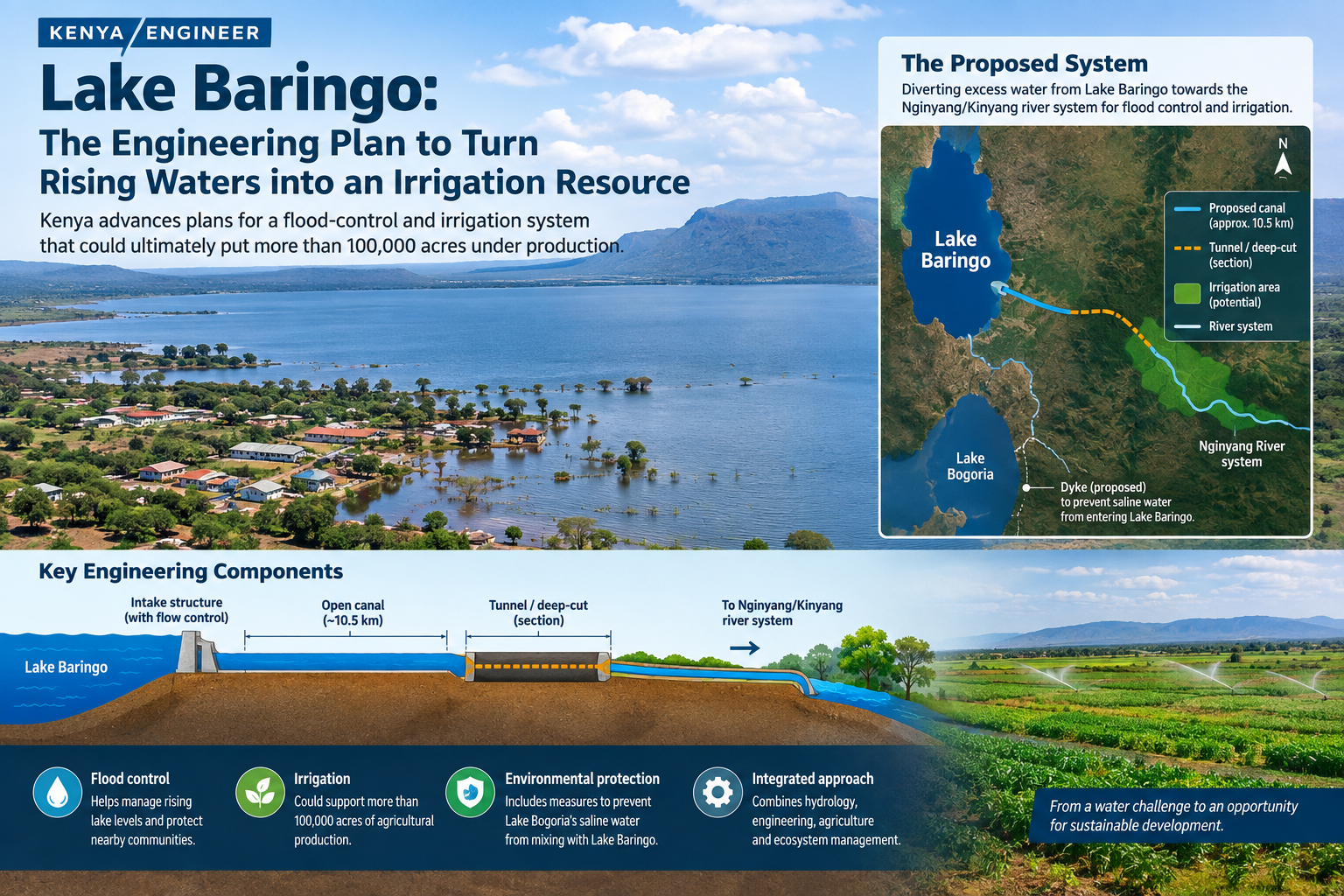
According to government officials, the proposed interventions include flood-control works, water conveyance infrastructure and irrigation development. The government is also considering measures to prevent the waters of Lake Bogoria from mixing with those of Lake Baringo as the two lakes continue to expand.
Lake Baringo is a freshwater lake, while Lake Bogoria is saline and alkaline. Their eventual interaction would have potentially significant ecological consequences, making the management of the two water bodies an important environmental as well as engineering consideration.
The canal and the Nginyang system
One of the most interesting engineering elements under consideration is the proposed conveyance of water from Lake Baringo towards the Nginyang/Kinyang river system.
Recent technical assessments have identified a possible route involving an approximately 10.5-kilometre open canal, together with tunnel or deep-cut sections forming part of the wider water-conveyance system.
The intention is not simply to release water downstream.
The system would need to regulate flows and convey water in a controlled manner, linking the flood-management function with the proposed irrigation development.
That distinction is important.
A drainage channel is designed primarily to remove water. An irrigation conveyance system has a very different engineering objective: it must move a predictable quantity of water safely and efficiently to where it can be used.
The proposed Lake Baringo system therefore presents engineers with a combination of flood-routing, hydraulic conveyance and irrigation challenges.
How much water can the system move?
The scale becomes clearer when the proposed flows are considered.
Technical assessments have examined flows in the region of tens of cubic metres per second, with recent government discussions putting the potential design flow at approximately 41 cubic metres per second.
At that scale, the project is far removed from an ordinary agricultural canal.
The hydraulic design would have to consider the canal’s gradient, cross-sectional dimensions, velocity, erosion protection, sediment movement and control structures. Engineers would also need to consider how the diverted water interacts with the receiving river system.
If tunnel or deep-cut sections are incorporated, geological investigations become equally important.
The design therefore has to answer several questions simultaneously: how much water should be removed from the lake, at what rate, through which route and under what conditions?
These questions are particularly important because Lake Baringo’s water levels are not static.
Why Lake Baringo has been rising
The expansion of Lake Baringo is not simply a question of excess water arriving during one rainy season.
Scientific studies have linked the lake’s changing extent to a combination of climatic and catchment factors, including increased rainfall and changes in land use within the surrounding watershed.
The result has been a major expansion of the lake’s surface area and the inundation of land around its former shoreline.
That creates a difficult engineering problem.
The solution cannot simply be to remove water whenever the lake rises. Engineers must understand the lake’s inflows, evaporation, catchment response, seasonal variation and long-term hydrological behaviour.
Otherwise, a flood-control intervention could be designed around conditions that may not represent the lake’s future behaviour.
An agricultural opportunity
The irrigation component gives the project its economic dimension.
Baringo already has experience with irrigation agriculture through schemes such as Perkerra, where water from River Perkerra supports thousands of farmers.
The National Irrigation Authority says Perkerra currently has 2,750 acres under irrigation within a gazetted area of 5,800 acres and supports about 1,625 farming households. The Authority is also looking at major expansion of irrigation in the area, including the proposed Radaat Dam and the use of solar-powered pumping to access Lake Baringo water.
The Lake Baringo proposal could therefore build on an existing agricultural and irrigation base rather than introducing irrigation into an entirely new environment.
Government projections for the wider Lake Baringo initiative are considerably larger, with officials talking about the potential to support more than 100,000 acres of irrigation in Baringo and potentially neighbouring areas, including parts of Turkana.
That scale could have significant implications for food production, employment, agro-processing and rural incomes.
But it would also require equally substantial investment in farm-level irrigation infrastructure, roads, electricity or solar pumping systems, storage, markets and agricultural extension.
A canal alone cannot create an irrigation economy.
The environmental question
The biggest test of the proposal may ultimately be environmental rather than hydraulic.
Lake Baringo supports fishing, livestock keeping, tourism and other livelihoods, while the wider basin contains important ecosystems.
Any intervention that changes the lake’s water level or alters downstream flows therefore has consequences beyond the immediate project area.
The relationship between Lakes Baringo and Bogoria makes the issue even more complicated.
Government plans have included consideration of a dyke at Lake Bogoria to prevent saline water from entering the freshwater Lake Baringo system. Officials have described this as part of a wider strategy to manage the changing relationship between the two lakes.
This means that the project will require careful environmental assessment alongside its hydraulic and geotechnical investigations.
The objective cannot simply be to move water from one location to another.
It must be to change the water balance in a way that protects communities while preserving the ecological functions of the basin.
The project is still being developed
Despite the growing attention around the proposed canal and irrigation system, it is important to distinguish between an announced project concept and a completed engineering design.
As of August 2026, the government was reviewing technical assessments, undertaking further consultations and working towards detailed feasibility studies and resource mobilisation.
That means key questions around the final route, design capacity, construction cost, financing structure, environmental safeguards and implementation arrangements still require resolution.
This is not unusual for a project of this scale.
Large water infrastructure projects can take years to progress from hydrological investigations and feasibility studies to detailed design, financing, procurement and construction.
What is significant at this stage is that Kenya is moving towards a defined engineering concept for dealing with a water problem that has been growing for years.
Engineering a different future for Baringo
The Lake Baringo proposal illustrates a broader principle in water engineering: a resource can become a hazard when it is uncontrolled, but the same resource can become an economic asset when it is properly managed.
For communities around Lake Baringo, the immediate concern has been the loss of land and infrastructure to rising water.
For planners and engineers, however, the challenge is more complex.
They must determine how much water the lake can safely lose, how that water can be conveyed, where it should go, how downstream systems will respond and how the resulting water supply can be converted into productive irrigation.
If the project eventually moves from feasibility studies to implementation, it could become one of Kenya’s largest attempts to combine flood management with irrigation development.
The ambition is therefore much greater than building a canal. It is about redesigning the relationship between a changing lake, its surrounding communities and one of the country’s most important agricultural frontiers.

-
Product on sale
 AWEBook Volume 2Original price was: KShs 3,500.00.KShs 3,000.00Current price is: KShs 3,000.00.